


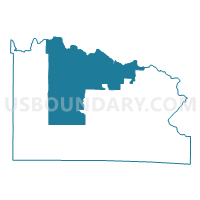
FLORENCE - T 5 Voting District, Florence County, Wisconsin
About
Outline

Summary
| Unique Area Identifier | 693707 |
| Name | FLORENCE - T 5 Voting District |
| County | Florence County |
| State | Wisconsin |
| Area (square miles) | 120.22 |
| Land Area (square miles) | 118.66 |
| Water Area (square miles) | 1.57 |
| % of Land Area | 98.70 |
| % of Water Area | 1.30 |
| Latitude of the Internal Point | 45.94733440 |
| Longtitude of the Internal Point | -88.44486810 |
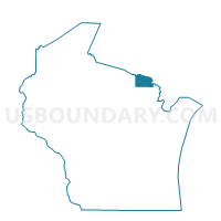
Maps

Graphs
Select a template below for downloading or customizing gragh for FLORENCE - T 5 Voting District, Florence County, Wisconsin


Neighbors
Neighoring Voting District (by Name) Neighboring Voting District on the Map
- Voting District 0715230000001, Iron County, MI
- Voting District 0717608000001, Iron County, MI
- COMMONWEALTH - T 1 Voting District, Florence County, WI
- FENCE - T 1 Voting District, Florence County, WI
- FERN - T 1 Voting District, Florence County, WI
- FLORENCE - T 1 Voting District, Florence County, WI
- FLORENCE - T 3 Voting District, Florence County, WI
- FLORENCE - T 4 Voting District, Florence County, WI
- FLORENCE - T 7 Voting District, Florence County, WI
- LONG LAKE - T 1 Voting District, Florence County, WI
- TIPLER - T 1 Voting District, Florence County, WI
Top 10 Neighboring County Subdivision (by Population) Neighboring County Subdivision on the Map
- Florence town, Florence County, WI (2,002)
- Stambaugh township, Iron County, MI (1,140)
- Mastodon township, Iron County, MI (656)
- Commonwealth town, Florence County, WI (399)
- Fence town, Florence County, WI (192)
- Fern town, Florence County, WI (159)
- Long Lake town, Florence County, WI (157)
- Tipler town, Florence County, WI (142)
Top 10 Neighboring Place (by Population) Neighboring Place on the Map
Top 10 Neighboring Unified School District (by Population) Neighboring Unified School District on the Map
- West Iron County Public Schools, MI (7,370)
- Forest Park School District, MI (4,447)
- Florence School District, WI (4,423)
Top 10 Neighboring State Legislative District Lower Chamber (by Population) Neighboring State Legislative District Lower Chamber on the Map
Top 10 Neighboring State Legislative District Upper Chamber (by Population) Neighboring State Legislative District Upper Chamber on the Map
Top 10 Neighboring 111th Congressional District (by Population) Neighboring 111th Congressional District on the Map
Top 10 Neighboring Census Tract (by Population) Neighboring Census Tract on the Map
- Census Tract 4, Iron County, MI (2,748)
- Census Tract 1901, Florence County, WI (2,603)
- Census Tract 5, Iron County, MI (2,469)
- Census Tract 1902, Florence County, WI (1,820)